
Questions about Nexar LiveMap? We’ve got answers
What is Nexar?
Nexar’s mission is to eliminate road collisions world-wide by alerting drivers to dangers ahead in real-time. When people pair a Nexar-powered smart dash cam with the Nexar app, they join Nexar’s connected vehicle network, where every vehicle is learning in real-time about what’s happening on the road thanks to the other vehicles around it. And now that our community is large enough, we’ve started rolling out new alerts to drivers before they reach hazards on the road ahead. This means we are starting to realize the future that we set out to build — a connected network that can actually make our roads more efficient, and save lives.
What is Nexar LiveMap?
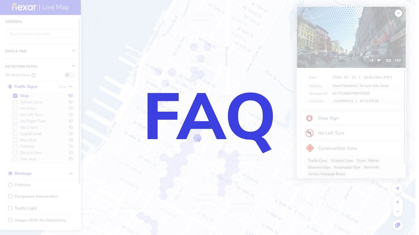
Nexar LiveMap is an important next step in our journey. It is a free, interactive digital map made of billions of real-time images and metadata from Nexar smart dash cameras on the road. It allows people to explore every corner of their cities as they exist today, filtering for things like construction zones, potholes, traffic lights and more.
Why does Nexar LiveMap matter?
Nothing like this exists in digital mapping. Images found on Apple Maps Look Around or Google Street View, the pre-eminent digital mapping tool, are often months or years old — making it an outdated source of information. Nexar LiveMap is updated constantly, making the insights from our connected vehicle network now available to everyone.
What is Nexar LiveMap used for?
It’s for cities, municipalities, and mobility and mapping companies that want to make our roads run more efficiently. It’s also for all of us. We see any number of use cases for this. Apartment hunters can avoid neighborhoods with work zones and loud late-night spots. Drivers challenging a ticket can look back in time to the incident and double check the road signs. Producers looking for images of a news event can get multiple perspectives on a story — like last weekend’s NYC blackout.
How does Nexar LiveMap protect the privacy of people driving with Nexar?
Privacy is the top priority for the entire Nexar team. Here is how Nexar LiveMap is designed to protect the privacy of Nexar users:
- Nexar LiveMap automatically blurs people’s faces and vehicles’ license plates.
- All images and data found on Nexar LiveMap are completely anonymized. No one will know which dash cam they originate from.
- Nexar LiveMap only selects a few frames from a single ride or a driver to make it impossible to “reverse engineer” the identity of the driver or track their rides.
- Nexar LiveMap automatically eliminates frames from where a person starts or ends their ride. This means, for example, that there will never be images of a person pulling into their garage or up to work.
- Nexar LiveMap has extremely lightweight artificial intelligence models that analyze the frames to eliminate any images from cameras that are not facing the road.
- No one has access to a Nexar driver’s personal data except for the driver. We are proud to abide by EU’s GDPR standards, and provide all Nexar drivers with strict data protection regardless of lesser local legal requirements. Here is our privacy policy and here is our ethical pledge for data usage.
Do I have to pay for Nexar LiveMap?
No. We chose to make Nexar LiveMap free to the public because we wanted to make the benefits of our connected vehicle network available to all. Cities, municipalities, and mobility and mapping companies that would like to access more data can do so by emailing us at citystream@getnexar.com. The information that we share with our partners is fully anonymized and aggregated, so that it cannot be re-identified. Again, no one will ever have access to a driver’s personal data except for the driver.
What if there are images that I find offensive or inappropriate?
In order to protect privacy, our models are optimized to be city specific. This allows Nexar to create a custom city filter to prevent offensive or inappropriate data from appearing on Nexar LiveMap. This includes automatically blurring faces and license plates. But if you do find anything that concerns you, please use the “Flag” icon to report and notify us of the frame you find inappropriate.
Why are you only launching this for New York City?
For privacy reasons. The artificial intelligence models that we train for blurring faces, license plates, and many other personal indicators are based on features that are specific to a certain city or town. In New York City, for example, there are lots of red brick buildings and specific kinds of license plates. We plan to train city-specific AI models for the entire US before opening LiveMap to other areas of the country.
I use Nexar in my vehicle. Can I opt-out of contributing to LiveMap?
Yes. If you don’t want to contribute to Nexar’s safe-driving network, you can email us and we will help you opt-out.
I have a question that you didn’t get to.
Email us at support@getnexar.com and we’ll get back to you asap.
You can also read our CEO’s blog post about the Nexar LiveMap announcement.